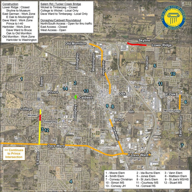
Please review this citywide view of road closures and work zones to prepare for the first week of school. This list does not include projects led by Conway Corporation, AT&T, Summit Utilities, or Ritter Communications. Click here to download the map in high resolution.
SALEM RD BRIDGE AT TUCKER CREEK
- Salem Rdclosed from Wicket St to Timberpeg Ct
- Salem Rd open to local traffic from College Ave to Wicket St and Timberpeg Ct to Dave Ward Dr
DONAGHEY/CALDWELL/WESTERN ROUNDABOUT
- Donaghey Ave open northbound and southbound
- Caldwell St closed from Donaghey Ave to Watkins St
- Western St open from Prince St to Donaghey Ave
- Southbound turn open from Western St onto Donaghey Ave
- Northbound turn closed from Caldwell St onto Donaghey Ave
LOWER RIDGE RD
- Lower Ridge Rd closed to thru traffic from Skyline to Museum
E GERMAN LN
DAVE WARD DR
- Asphalt overlay, striping, marking (ArDOT) from Prince St to I-40 in the evening hours
HARKRIDER ST (HWY 65)
- Asphalt overlay, striping, marking (ArDOT) from Dave Ward Dr to Bruce St in the evening hours
- Asphalt overlay, striping, marking (ArDOT) from Oak St (Hwy 64) to Old Morrilton in the evening hours
OLD MORRILTON
- Asphalt overlay, striping, marking (ArDOT) from Harkrider (Hwy 65) to Washington Ave in the evening hours
