The Geographic Information System (GIS) department within the Planning & Development department oversees assigning, maintaining, and updating addresses for the city of Conway. City GIS works with Conway Corporation, the United States Postal Service, the dispatch center, Faulkner County OEM/911 and the Faulkner County Assessor’s Office to make sure addresses are assigned correctly and logically. Addresses are regularly provided to the emergency services dispatch center, who give feedback when there is trouble locating an address that was provided in a 9-1-1 emergency call.
Streets and addresses can be viewed on the city’s Master Map, here or e-mail gis@conwayarkansas.gov for an official address verification or questions.
When new subdivisions and developments go through the planning review process, the GIS office is involved by helping ensure that street names are not duplicated within the city, or even the county if possible. The streets’ layout is reviewed to make sure that it will be easy to navigate and assign addresses.
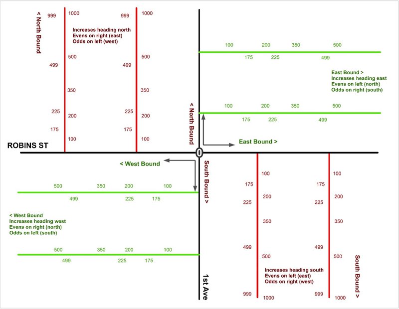
Conway has historically been split into a loose grid, the center of which is the 0-point for addressing, with numbers increasing from that central location. This grid also determines when a street name should include an east or south prefix. When the street is long enough to cross east or south over one of the dividing lines, its name is changed to include “E” or “S”. Keep in mind, there are instances where a direction is in the street’s actual name and not just a directional prefix, such as East German Ln.
The North-South dividing line is Robins St, with streets crossing south over Robins St having ‘S’ assigned as a directional prefix…such as Salem Rd and S Salem Rd. The East-West dividing line is 1st Ave, with streets to the east of it having an ‘E’ prefix…such as Oak St and E Oak St.
It is important to know the actual name of your street, as it can affect mail delivery and particularly the response time by the fire or police departments when an emergency 9-1-1 call is placed.
As with streets, assigning addresses is based on the grid created by Robins St (N/S) and 1st Ave (E/W). New subdivisions are addressed during the review process and are typically listed on the filed plat.
Addresses north of Robins St, as the N/S dividing line, will increase with evens on your right (east side) and odds on your left (west side). When heading south, the address numbering flips as well, with evens on your left (east side) and odds on your right (west side).
On roads that run east-west, addressing follows a similar pattern, with 1st Ave as the E/W dividing line. Addresses increase when heading east from 1st Ave, with evens on your left (north side) and odds on your right (south side). If heading west from 1st Ave, the addresses flip so that evens are on your right (north side) and odd numbers are on your left (south side).
With addresses, the direction that you are headed in effects which side that odd and even numbers are compared to you. But it can be helpful to remember that directionally, evens are always on the north or east side of a road while odds are always on the south or west side of a road. So, when heading north-south, evens are always on the east and odds are on the west. And when heading east-west, evens are intended to be on the north and odds on the south side of the road.