
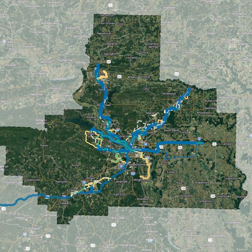
Metroplan invites the public to review and comment on proposed routes for its Regional Greenways (trails) Plan. From Fiscal Year 2021 through Fiscal Year 2031, Metroplan will target approximately half its Surface Transportation Program Block Grant (STPBG) funding toward building the greenways system. The Plan will inform these investments.
The public is encouraged to access the interactive map at: https://www.centralarkgreenways.com/interactive-map. Once on the site, users can read more about the project and view the route map in great detail. Comments can be placed anywhere along routes by either clicking the route segment of the user’s choice or clicking the red Add a Comment button above the map legend.
Metroplan is the federally designated metropolitan planning organization for the four-county region of Faulkner, Lonoke, Pulaski and Saline counties. It is a voluntary association of local governments that has operated since 1955. For more information go to metroplan.org.
This planning study will outline future paved bicycle and pedestrian paths and trails, called greenways, to connect Pulaski, Faulkner, Lonoke, and Saline Counties. Metroplan, the region’s planning organization, dedicated substantial funding to construct greenways that increase local and regional connectivity and mobility, while fostering economic development, quality of life, and recreation opportunities.
Mayors, county judges, engineering and planning professionals and other community leaders across the four-county region have spent countless hours in meetings determining the most alluring and viable routes that you see on the webmap.
A greenway is a large, paved path, measuring between 12 and 14 feet wide, that is physically separated from a street. Think of it as a mini road only for walkers and bicyclists or other non-motorized vehicles.
Greenways will often follow waterways and other natural environments not accessible to cars, but sometimes follow alongside roadways. The system will be separated paths, except for a few constrained locations where on-street bicycle facilities may be necessary.
We want your thoughts on route locations, additional destinations that should be considered, and any other suggestions for potential connection opportunities. Routes shown on the map are the result of input from the Greenways Steering Committee and local leadership and are now being made available for your input.